Virtual Buffalo Bill’s Wild West

My colleague James Connolly and I, working with staff from the Buffalo Bill Center of the West, and artists and designers from Ball State’s Institute for Digital Intermedia Arts (IDIA), have crafted a computer-generated world that authentically simulates the Wild West show dramatizing frontier life. Virtual Buffalo Bill’s Wild West is a multiplayer virtual world that simulates Buffalo Bill Wild West Show circa 1899. The project serves as a prototype for developing and testing various designs and configurations that integrate a 3D environment and a web-based digital archive. This digital history project is built in Unity 3D using custom software created by IDIA Lab. The archive employs the Collective Access content management system, using VRA Core standards.

This collection contains source materials for the three-dimensional recreation of Buffalo Bill’s Wild West and Congress of Rough Riders of the World, a traveling exhibition that toured North America and Europe between 1883 and 1908. This enormously popular show presented to its audiences a recreation of life in the Old West, complete with spectacular displays of riding and shooting, as well as performances by “rough riders” from around the world. In addition to materials used as the basis for the design of the virtual world, this archive contains primary sources that provide historical context for understanding the Wild West show, its role in creating popular images of the Old West, the social history of the era.

Introduction – Verónica Reyes-Escudero

It is a pleasure for me to participate in this year’s Six-Shooters Lightning Round. I am the Borderlands Curator and Associate Librarian at the University of Arizona Libraries’ Special Collections. We’re located in beautiful Tucson, Arizona just 90 miles from the U.S. – Mexico border. I work with faculty and students across disciplines in using special collections materials and engage with the community through donor relations and events highlighting the archive’s rich holdings on the U.S.-Mexico borderlands. I’ve written and presented on incorporating archives-based research into the curriculum, newspaper digitization, and the archives of Mexican American literary authors.

As for my six minutes, six slides, I’ll be presenting on The Documented Border Archive. The project is an interdisciplinary effort to advance understanding about the U.S. – Mexico border and its peoples during a period of unprecedented change. A unique aspect of the project is that it is a living archive. Archives struggle to include the voices of underrepresented communities. The Documented Border collects, preserves, and affords access to just such voices for study and research, now and in the future. The genesis of the project involved Drs. Celeste Gonzalez de Bustamante and Jeannine Relly from The School of Journalism; Fine Arts faculty, Lawrence Gipe; and Borderlands Curator Verónica Reyes-Escudero, Special Collections, University of Arizona Libraries.
Currently, the archive content takes two forms: interviews and images. Interviews include Mexican and U.S. journalists who cover northern Mexico and human rights activists dedicated to improving freedom of expression. Journalists discuss kidnapping attempts, threats of violence, and lack of security and freedom of expression, in some cases, leading to self-censorship. The archive also contains a collection of sketches of migrants sentenced in federal immigration court under “Operation Streamline.” These are some of the only visual representations of these proceedings, as cameras are forbidden in all federal courts, putting a face to migrant deportations.

Cameron Blevins, The Postal West

I am a digital historian studying the nineteenth-century United States and the American West. My current position is Andrew W. Mellon post-doctoral fellow at Rutgers University’s history department and the Rutgers Center for Historical Analysis. Before this, I received my Ph.D. from Stanford University, where I worked at the Spatial History Project and Center for Spatial and Textual Analysis (CESTA).Some of my broader interests include geography, communications, gender history, and information visualization.

At the six shooters session I’ll be giving an overview of my research project, “The Postal West,” which tells a spatial history of the role of the U.S. Post in the integration of the American West. Digital analysis has bee a key part of this project, including building an interactive map with Jason Heppler, Jocelyn Hickox, and Tara Balakrishnan that visualizes the opening and closing of more than 14,000 post offices across the western United States. Rather than focus on the digital methods themselves, however, I’d like to try and convey the big interpretive results and arguments that I’ve made using these kinds of tools.

Crafting a Digital Denver: Virtual Spaces and Undergraduate Teaching

Hello! To introduce myself, I currently teach as a special instructor in the History Department at Colorado State University (CSU), where I specialize in digital history and the history of Mexico. Over the years, I’ve utilized a number of digital tools and publication platforms in my classes, but nothing quite like Minecraft.edu, which is the subject of this talk. During the spring 2015 semester,  students in my upper-division course on digital history worked with resources from the Denver Public Library’s collection of Sanborn maps and digital photographs, Colorado State Library’s newspaper archive, and an ed-tech version of the immensely popular video game Minecraft to create a 100% scale, virtual facsimile of the city of Denver at the dawn of the twentieth century. In addition to intensive training in interpreting the complex maps needed to faithfully recreate the cityscape down to the brick, students were individually tasked with researching thematic topics from within the social, economic, political, and cultural history of the city and the larger U.S. West.

This multifaceted, multimedia exploration of the urban history of Denver will then be published on a class Tumblr account and web links to the visual and written materials will be placed within the game environment to allow the viewer the potential for a more in-depth exploration and understanding of the spaces of this rapidly-expanding city. However, given the time-intensive nature of this kind of ambitious project, it will not be possible to complete it in a single semester. Our projected launch date is currently the year 2020, but we do plan to release updated versions of the map on a yearly basis to be shared with libraries, schools, and the general public, allowing a unique opportunity for any interested parties to virtually immerse themselves within the living landscape of the city of Denver as it was over a century ago. 

Visualizing Urban Change in Silicon Valley

Greetings all! I am Jason Heppler, a Ph.D. candidate at the University of Nebraska-Lincoln and the Academic Technology Specialist for the Department of History at Stanford University, where I mostly work on evidence visualization projects and teach digital history. My dissertation, “Machines in the Valley: Growth, Conflict, and Environmental Politics in Silicon Valley” examines contested ideas about space and place as the cities of Silicon Valley grew during the postwar era. These debates gave expression to what I see as environmentalism growing out of specific local concerns, as well as a burgeoning discussion about sustainable cities.

For the Six Shooters, I wanted to talk about some of the data visualization projects I’ve been working on for the digital components of my dissertation. I’m curious to hear your feedback — what works, what doesn’t, what’s missing. In particular, I was interested in trying to examine the spaces of the cities ignored or overlooked by city planners and the reasons behind their absence. I have anecdotal evidence suggesting the uneven (and unequal) patterns of municipal expansion, but by visualizing this unevenness I suggest we can better see the spaces of the city that were given the most attention and the reasons behind their focus.

Creating Citizen Archivists

Slide1

Fortepan Iowa and the Making of Kronofoto


Fortepan Iowa is a research-based, student-centered project conducted at the University of Northern Iowa between three different departments, in two different colleges, across four different disciplines. Bettina Fabos in visual communications and Sergey Golitsynskiy in computer science, from the Communication Studies Department, Noah Doely in photography from the Art Department, and myself in public history, from the Department of History are working to create an interactive digital platform for collecting, archiving, displaying, and utilizing amateur photographs of Iowa’s past.

Slide2

The project embodies our individual specialties in creating digital platforms, collecting and documenting historical images, and displaying and interpreting those images, and it represents our collective commitment to open-source platforms and to student training. It also showcases the history of Iowa because the images it contains are of events and places throughout the state taken between 1860 and 2000, the era of print photos.

The name of the project itself, “Fortepan,” comes from the widely popular film paper made by the Hungarian company Forte and stands in for the idea of amateur photography. Fortepan Iowa is the sister site to the original Fortepan project.


Slide3

The Fortepan Concept

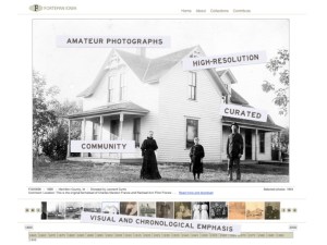
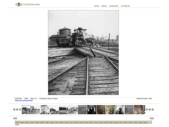
The project is designed to showcase the snapshot, the ubiquitous window into the life of the ordinary citizen. The images featured on the project’s homepage have been curated for their aesthetic and documentary value. These images are arranged photograph by photograph chronologically along an interactive timeline, which users can use to browse through the collection year by year. All the images are scanned at a high resolution and available for download and use under the Creative Commons Attribution-Share Alike 4.0 International Public license. These ideas collectively comprise what we call the Fortepan Concept.

Our students have largely been responsible for the core of the collections by documenting and digitizing these photographs from their own families and communities. In doing so, they have not only built a digital archive from the ground up, they have learned much about digital platforms and culture, archival and collections work, and working collaboratively.


Slide4

Kronofoto

The platform itself, called Kronofoto, is an original work unique to the project. The project collaborators have engineered it from the ground up to privilege the visual image, similar to the original Fortepan, but to also interpret the collections in a variety of ways. Currently, users can browse the images chronologically along the timeline, through individual collection, and by donor. But we designed Kronofoto to be highly malleable.

We are currently working on a spatial interpretation of the collections through an interactive map of the state and tagging individual images so that users can browse them by subject. We will also be adding excerpts from oral history interviews to some images to allow users to listen to the stories that accompany these photographs. Lastly, we are continuing to add to the collections by integrating all the donated images, including those not featured on the homepage. We intend to allow users to contribute their own images and stories, thereby making the project’s platform a bridge between professional archiving and citizen participation such that it becomes a pathway to create citizen archivists and empowers communities to document their own history for themselves.


Slide5

The project has been funded by Humanities Iowa and through a university Capacity-Building grant and it launched in March 2015. To date, the Fortepan Iowa project has involved more than 165 students, worked with 200 donors, and collected and digitized almost 5500 images, nearly 2000 of which are currently featured on the public website. We are continuing to grow the archive, to improve the digital interface, and to use it to train and educate new cohorts of students. We will also be applying for grants from the National Endowment for the Humanities to continue to fund the project’s infrastructure and to prepare the Fortepan Concept and Kronofoto for public release.

Lineup for WHA 2015 Six-Shooters Session

Here are the presenters that we have confirmed for the Technology Committee sponsored session Six-Shooters: A Digital Frontiers Lightning Round Session:

  • Cameron Blevins, Rutgers University
  • Leisl Carr-Childers, University of Northern Iowa
  • Jason Heppler, Stanford University
  • Robert Jordan, Colorado State University
  • Verónica Reyes-Escudero, University of Arizona
  • Douglas Seefeldt, Ball State University

The session will be chaired by Douglas Seefeldt, Ball State University and is scheduled for Friday, October 23 from 2:30-4:00 PM in Parlor C of the Hilton Portland & Executive Towers, Portland, Oregon. Please check this site in the days leading up to the conference for introductions by each presenter and brief descriptions of the work they plan to present.

A View into the 2014 WHA Six-Shooters digital history session

This year’s Six-Shooters digital history lightning round session, sponsored by the WHA Technology Committee, featured nine presenters sharing their research, teaching, and public projects (photos by Doug Seefeldt, session chair):

Introductions – Rebecca S. Wingo

I’m pleased to be a new contributor on the blog and a panelist at this year’s Six-Shooters Lightning Round.  (The main reasons I signed up for this session is because the title makes me think of Yosemite Sam.)

I am currently a Ph.D. Candidate in the Department of History at the University of Nebraska-Lincoln, and will graduate in May 2015 with two graduate certificates in Digital Humanities and Great Plains Studies.  My dissertation, “Restructuring the Reservation: Housing, Hygiene, and Domesticity on the Crow Reservation, 1880-1934,” examines house-building policy as an imposition of a larger project of cultural imperialism by enforcing Christian concepts of domesticity, gender, and hygiene on indigenous communities.  The project introduces a unique set of photographs emerging from the Crow Reservation to examine signs of Native interruption to federal assimilationist policy.

More specific to the Six-Shooters Lightning Round, I have been working with a research team at the Center for Great Plains Studies to reassess the Homestead Act of 1862 based on the now-digitized NARA records for the State of Nebraska.  We are preparing a manuscript (publisher TBA) for completion in 2015.  The presentation, “Can I Get a Witness?: Network Analysis of Homesteaders in Nebraska,” examines a network forged legally between witnesses under the Homestead Act.  Essentially, the Land Office required each homesteader to list four witnesses in a Proof of Posting which ran for five weeks in a local newspaper.  While only two witnesses were required to testify at the Land Office, mapping all four connections reveals community formation, local leadership, and settlement patterns of neighborhoods in the rural plains.  I created a digital companion to our manuscript, and while it is waiting for final review and a permanent home, you’re welcome to view its nascent form here.

I look forward to my six-minutes and six-slides of fame this coming Thursday!

WHA 2014 Six-Shooters Session – Robert Jordan

Prior to the Six-Shooters session at this year’s WHA conference, I would like to introduce myself and some of the work I’ve been doing over the last year or so. I am a third-year instructor in the History Department of Colorado State University, specializing in Mexican history and digital history. Digital history, especially as expressed through spatial visualizations, plays a prominent role in both my research and teaching, as I believe that traditional methods of historical inquiry and publication can be greatly augmented by the incorporation of digital tools. I have utilized a number of digital tools and publication platforms in my classes, including: Twitter, Neatline, Voyant Tools, Tiki-Toki, Wikipedia, Gephi, Open Refine, Tumblr, ArcGIS, Google Earth, WordPress, SketchUp, and 3-D printing, among others.

While teaching the first undergraduate digital history course ever offered at CSU in the spring of this year, my students trained and published a wide variety of information on the history of the university and campus life. Digital timelines, maps, slideshows, and network graphs were created to be later hosted by CSU’s university webpage and mobile app. The creation of these multimedia, highly visual presentations of local, public history challenged my students with a hands-on, collaborative project which pushed their limits but provided invaluable experience for the job market and/or graduate school. I look forward to discussing the challenges during the planning and execution of this project, the pedagogical outcomes for my students, and the future of scholarly innovation inside and outside the history classroom.